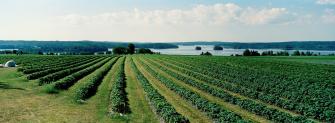
Visual monitoring of landscapes

The monitoring is based on photographs taken every 5–10 years, illustrating changes in the landscape. During the monitoring period, the rural landscape has been documented in thousands of photographs, which can be browsed in the media bank of the Natural Resources Institute Finland (currently under construction). The photographs are available for researchers, experts, teachers, and anyone interested in changing landscapes. The Natural Resources Institute Finland holds copyrights of the images.
The visual monitoring of landscapes consists of two independent parts. The majority of the images were taken at agricultural sites located at nationally valuable landscape areas or the study areas of the effectiveness of the national agri-environmental support scheme. The second part contains images of valuable traditional rural biotopes in the regions of Uusimaa and Pirkanmaa in Southern Finland. The material contains over 5,000 panoramic photographs, videos and 360° images.
Examples of time series can be viewed on this site, but currently only on Finnish language pages. Links 'Muuttuvat peltomaisemat' and 'Muuttuvat perinnebiotoopit' can be found on the left sidebar after changing language of the page.
Photographic method
Visual landscape monitoring is a systematic documentation of landscapes with photographs.
Photographing agricultural landscapes
The visual monitoring of agricultural landscapes has been carried out in 13 different locations, of which ten have been evaluated as Nationally Valuable Landscape Areas. In addition, monitoring took place in Kolari in 2010.
At each location, the photographs were taken from 7-13 individual observation points. These sites were selected from maps in such a way that they can be reliably relocated. At each site, four images were taken according to their cardinal points.
All photographic sites were documented initially in 1996, and rephotographed in the years 2000, 2005, 2010 and 2020. At few locations photographs were also taken at intermediate years 2001–2003. The photos from 1996 were produced on b/w material and possess a different image dimension. Pictures taken between 2000 and 2020 were photographed with similar panoramic cameras and are therefore suitable for comparison.
In 2020, the original imaging methods were supplemented by drone imaging. Drone was used to record 360-degree panoramas and videos as well as overflight photos of landscapes.
To date, the agricultural landscapes have been documented in almost 3,000 photographs.
Photographing traditional rural biotopes
The visual monitoring of traditional rural biotopes has been carried out at 48 different sites in the regions of Uusimaa and Pirkanmaa in Southern Finland. The sites had been classified as nationally valuable in the earlier inventory. The sites were also included in a biodiversity study conducted by the Finnish Environment Institute (Syke) in 2000–2004.
At each site the photographs were taken from four individual points. These points were located at each corner of the 50 by 50 meter research area used in Syke’s biodiversity study. Two photographs were taken from each point, one facing the corner to the left and the other one towards the diagonally opposite corner of the square. Therefore, on each visit eight photos were taken from each site.
All traditional biotopes were initially photographed in the year 2001, and rephotographed during 2006–2007, 2011–2012 and 2017–2019. At few sites photographs were also taken at intermediate years.
To date, the traditional rural biotopes have been documented in almost 2,500 photographs.
Background
The collection of visual landscape monitoring image data began in 1996 in the Visual monitoring of Finnish landscapes project. Landscape monitoring has also been carried out as part of the Monitoring of Impact of the Finnish Agri-Environmental Scheme: Monitoring of biodiversity and landscape (MYTVAS) research project. Since then, the Rural Women's Advisory Organization has carried out reshoots in cooperation with the Ministry of the Environment.
Visual monitoring of Finnish landscapes project (in Finnish)
- Heikkilä, T. 2007a. Visuaalinen maisemaseuranta: kulttuurimaiseman muutosten valokuvadokumentointi. Tekstit. Musta taide, Helsinki.
- Heikkilä, T. 2007b. Visuaalinen maisemaseuranta: kulttuurimaiseman muutosten valokuvadokumentointi. Kuvat. Musta taide, Helsinki.
- Soini, K., Pouta, E., Kivinen T., Uusitalo M. (toim.). 2008. Maaseutumaiseman muutos, arvottaminen ja eurooppalainen maisemayleissopimus. Maa- ja elintarviketalous 135.
Monitoring of Impact of the Finnish Agri-Environmental Scheme (MYTVAS) project (in Finnish)
- Heikkilä, T. 2008. Maatalousmaiseman visuaalinen seuranta 1996–2006. Sivut 176–181 teoksessa Kuussaari, M., Heliölä, J., Tiainen, J. & Helenius, J. (toim.): Maatalouden ympäristötuen merkitys luonnon monimuotoisuudelle ja maisemalle. MYTVAS-loppuraportti 2000-2006. Suomen ympäristö 4/2008.
- Heikkilä, T. & Hietala-Koivu, R. 2004. Maatalousmaiseman visuaalinen seuranta. Sivut 141-152 teoksessa Kuussaari, M., Tiainen, J. & Helenius, J., Hietala-Koivu, R. & Heliölä, J. (toim.). Maatalouden ympäristötuen merkitys luonnon monimuotoisuudelle ja maisemalle. MYTVAS-seurantatutkimus 2000-2003. Suomen ympäristö 709.
- Heikkilä, T. & Helenius, J. 2010. Ympäristötuen merkitys visuaaliselle maisemalle. Sivut 75–78 teoksessa Aakkula, J., Manninen, T. & Nurro, M. (toim.): Maatalouden ympäristötuen vaikuttavuuden seurantatutkimus (MYTVAS 3). Väliraportti. Maa- ja metsätalousministeriön julkaisuja 1/2010.
- Hietala-Koivu, R., Tahvanainen, L., Nousiainen, I., Heikkilä, T., Alanen, A., Ihalainen, M., Tyrväinen, L. & Helenius, J. 1999. Visuaalinen maisema maatalouden ympäristöohjelman vaikuttavuuden seurannassa. Maatalouden tutkimuskeskuksen julkaisuja. Sarja A, 50.
- Sillanpää, P., Hietala, R. & Heikkilä, T. 2014. Viljelymaisemien ja niittyjen kuva-analyysi. Sivut 157–165 teoksessa: Aakkula, J. & Leppänen, J. (toim.). Maatalouden ympäristötuen vaikuttavuuden seurantatutkimus. Loppuraportti (MYTVAS3). Maa- ja metsätalousministeriön julkaisuja 3/2014.
Photographers
Dr Tapio Heikkilä launched the Visual monitoring of Finnish landscapes project in 1996. His doctoral thesis, published in 2007, was based on this visual material. Heikkilä worked as an expert on landscape and environment conservation at the Finnish Ministry of the Environment.
MA Martina Motzbäuchel has participated in the visual monitoring of Finnish landscapes since 2005 by taking photographs and establishing the picture archive. Currently she works as a freelance photographer.
Oiva Hakala was a photographer in the Visual monitoring of Finnish landscapes project starting in 1996.
MA Antti Hahl was a photographer in the visual monitoring of Finnish landscapes in 2019.
Dr Reija Hietala took part in preparing and designing the project.